Route to Climb Mount Everest: South & North Guide

Mount Everest, the world’s tallest peak, is a magnet for mountaineers and trekkers from around the globe. At 29,035’/8,848m above sea level, Mt. Everest is the tallest mountain the world and sits directly on the border between Tibet and Nepal. To Tibetans, the mountain is known as Chomolungma, meaning “Mother Goddess of the World”; to the Nepalese, it is Sagarmatha, meaning “The Head in the Great Blue Sky”. The mountain exudes a spiritual magnetism and, as such, has a storied climbing history. Over the past century, two main Everest routes emerged: the South Col and the Northeast Ridge.
If you are aiming for Everest Base Camp or the summit, knowing the climbing routes is key to your journey.

The two main climbing routes on Mt. Everest.
The South Col Route of Everest
Teams start in Kathmandu and fly into Nepal’s Khumbu Valley, where they trek to South Side Base Camp of Everest (17,300’/5,273m) over a number of days to acclimatize. The Khumbu is incredibly beautiful and provides the opportunity to really immerse oneself in Sherpa culture, and the trek to base camp travels through several remote mountain locales along the way. South Side teams ascend via the Khumbu Icefall, Western Cwm, Lhotse Face, South Col, South Summit, Hillary Step, and then the summit. Typically, teams establish three camps on this route. These are Camp 2 at 21,500’/6,553m, Camp 3 at 23,500’/7,163m and High Camp at 26,300’/8,016m.
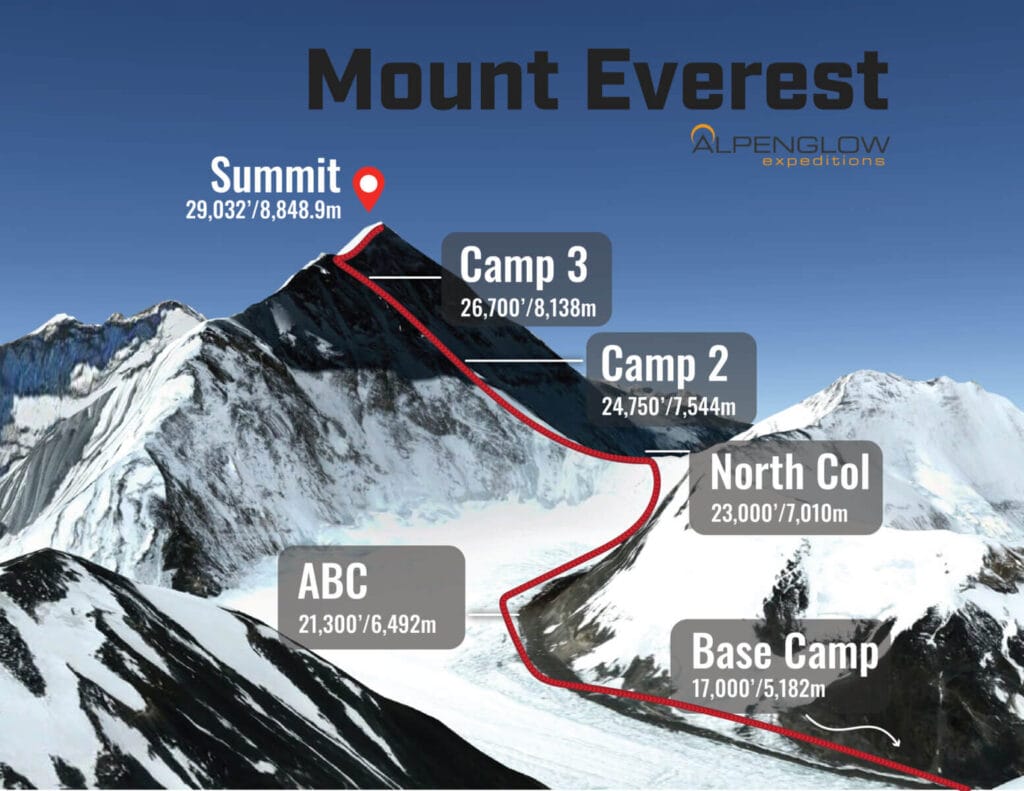
Everest Northeast Ridge
As the name implies, this route is on the north side of the mountain in Tibet. Alpenglow Expeditions has chosen to exclusively climb the Northeast ridge route on Everest because we feel it has less objective hazard (hazards beyond our control) and is less risky for our climbers, guides, and Sherpa. We begin our trip in Lhasa, Tibet and drive across the Tibetan Plateau to the North Side Everest Base Camp at 17,200’/5,243m. The drive spans three days, stopping in Shigatse and New Tingri (Shegar). From Shegar, we are able to drive directly into Base Camp. This approach allows us to better supply our base camp without needing to rely on transport by planes, porters, and yaks.
On Everest’s Northeast Ridge Route, teams typically establish an Advanced Base Camp (ABC) at 21,000’/6,401m, followed by 3 primitive, high-altitude camps above that. The terrain between EBC (Everest Base Camp) and ABC (Advanced Base Camp) is flat and glaciated, covered in scree and gravel. It’s uniquely beautiful, walled in by large waves of glacial ice on the fringes of the dirt. The mellow grade of the terrain makes it easy to transport gear back and forth between EBC and ABC, so we’re able to stock ABC with a full cook tent, dining tent, sleeping tents, and a lounge. We also have solar power and satellite wifi to stay connected.
Above ABC is where the real climbing and fixed lines begin. We establish our first primitive camp at the North Col (the col between Everest and Changtse) at 23,000’/7,000m. Camp 2 is established at 25,590’/7,800m on the rocky ridge between the North Col and the NE Ridge. It’s a barren camp, with tiny platforms of piled rocks just big enough for our tents. Above, Camp 3 is our final high camp sitting at 27,231’/8,300m. It is on a broad, steep, rocky face just below the NE ridge and mostly devoid of snow. The slope is steep, making it is difficult to pile rocks high enough to create a level platform the full size of a tent. As a result, the platforms end up only being wide enough for about two thirds of a tent- the rest just hangs down the slope.
1. Overview of Mount Everest Routes
Climbing Mount Everest is no easy feat, with numerous routes to the summit. The two main approaches are from the south route (via Nepal) and the north route (via Tibet).
Each route has its own challenges, altitude risks, and technical requirements.
“Climbing Mount Everest requires careful preparation, awareness of weather patterns, and a detailed understanding of the climbing routes.”
How Many Different Climbing Routes Are There on Mount Everest?
There are several routes to the summit, but the most commonly used are:
- South Col Route (Nepal): The most popular and widely used route, involving the classic path from Everest Base Camp.
- North Col Route (Tibet): A more difficult route, requiring crossing the Tibetan plateau and navigating the north side of Everest.
Other variations, such as the West Ridge and East Ridge, are considered less traveled and more technical.

2. Popular Climbing Routes
| Route | Starting Point | Difficulty | Key Features |
|---|---|---|---|
| South Col Route | Everest Base Camp (Nepal) | Moderate to Difficult | Most popular route, lower risk of avalanches |
| North Col Route | Tibet | Difficult | Fewer climbers, harsher weather conditions |
| West Ridge | South Col | Very Difficult | Steep, technical, and less crowded |
| East Ridge | Tibet | Very Difficult | Rarely used, technical challenges |
Each of these routes requires thorough planning and extensive mountaineering experience.

USD 9699993% off
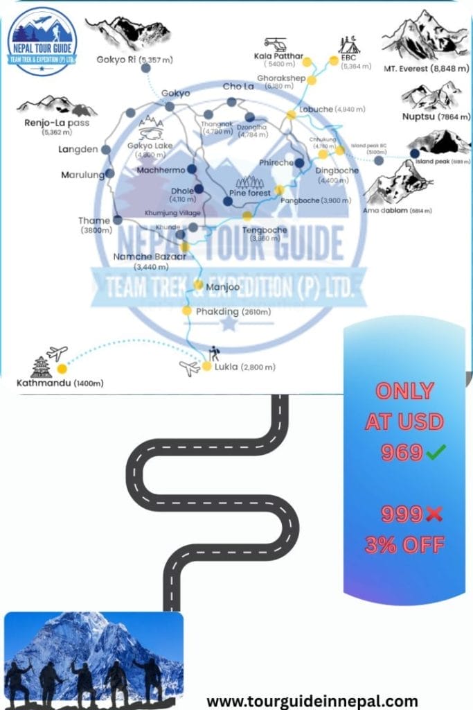
3. Everest Base Camp Trek Map
The trek to Everest Base Camp is the most popular way to experience the Himalayas without summiting. The Everest Base Camp map outlines the essential path, which passes through various villages, monasteries, and acclimatization stops.
“Trekking to Everest Base Camp is a once-in-a-lifetime experience, offering breathtaking views of Everest and the surrounding peaks.”
4. Climbing Routes and Summit Options
Reaching the summit of Mount Everest involves scaling through high-altitude camps:
| Camp | Altitude | Purpose |
|---|---|---|
| Base Camp | 5,364 meters | Starting point for trekking and climbing |
| Camp I | 6,065 meters | First stop before reaching the South Col |
| Camp II | 6,500 meters | Acclimatization point |
| Camp III | 7,470 meters | Final push before summit |
| Summit | 8,848 meters | The pinnacle of Everest |
Different climbing routes lead to these camps, with the South Route being the most used for summit attempts.
5. Essential Maps for Mount Everest Trekking and Climbing
Mount Everest routes are essential to understand whether you’re trekking to Everest Base Camp or aiming for the summit. The Mount Everest Route Map highlights the main ascent paths, while the Everest Camps Map shows key camp locations on both the south and north sides. For trekkers, the EBC Trek Map outlines the Base Camp trail and major landmarks. Moreover, the Everest Summit Routes Map details the climb from Base Camp to the summit via the South Col and North Col. Additionally, the Mount Everest Trail Map includes trekking routes and side trips like Kala Patthar. Lastly, the Hike to Everest Base Camp Map offers valuable altitude and trail insights for safe and successful trekking.
“Knowing the path to Everest Base Camp is essential for all trekkers; understanding the summit routes is key for climbers.”
6. FAQs About Everest Routes
1. What is the easiest route to Everest’s summit?
The South Col route from Nepal is the most common and considered the easiest, though it still presents significant challenges due to the altitude and weather.
2. How long does it take to trek to Everest Base Camp?
The trek typically takes 12 to 14 days, depending on your pace and acclimatization needs.
3. Are there any dangerous parts of the Everest routes?
Yes, areas like the Khumbu Icefall on the South Col route and the North Col route are particularly dangerous due to crevasses, avalanches, and unpredictable weather.
4. Can I hike to Everest Base Camp without a guide?
Yes, you can hike solo, but a guide is safer for navigation and support.

